Understanding the geopolitical landscape is key for today's globally aware citizen, and locating contested territories like Western Sahara on a world map is a crucial step. This guide cuts through the noise, providing a direct and clear explanation for Gen Z and Millennials who prioritize accurate, accessible information. Whether you are prepping for a quiz, following current events, or simply curious, knowing precisely where Western Sahara sits in relation to its neighbors and the broader African continent is essential. We will navigate its unique position, highlighting why its depiction often varies across different maps and how this impacts international understanding. Get ready to pinpoint this significant region and grasp the nuances of its geographical representation, ensuring you are always informed about its place in the world.
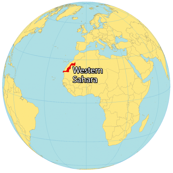
- Where is Western Sahara located on the world map? - Western Sahara is in North Africa, bordering the Atlantic Ocean. It lies directly south of Morocco, west of Algeria, and north of Mauritania. Its position is strategic, nestled between these countries and the vast expanse of the Sahara Desert.
- Why does Western Sahara appear differently on various world maps? - The varying depictions stem from its disputed political status. Morocco claims sovereignty, while the Sahrawi Arab Democratic Republic seeks independence. Mapmakers often use dashed lines or different shading to reflect this ongoing international debate rather than a recognized border.
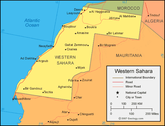
- How can I identify the key cities in Western Sahara using a map? - To find key cities, zoom in on the coastal areas of Western Sahara on your preferred map app. The largest city and de facto capital is Laayoune, located on the northern Atlantic coast. Dakhla is another significant city further south on a peninsula.
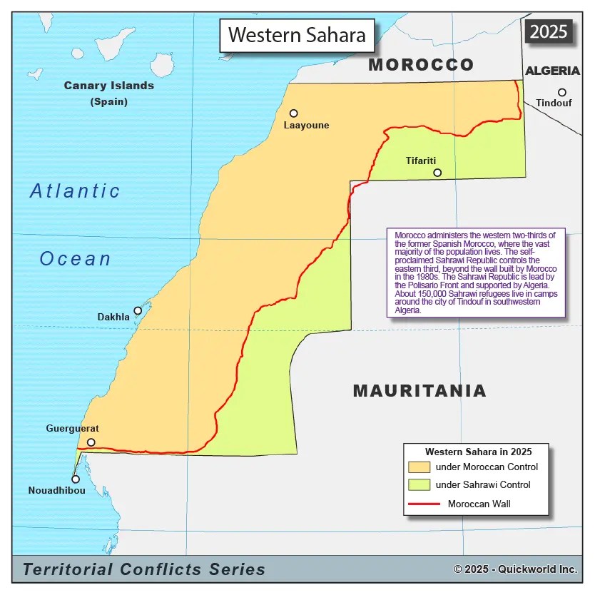
- What is the significance of the 'Berm' when viewing Western Sahara on maps? - The 'Berm' is a long sand wall constructed by Morocco, dividing Western Sahara. On detailed maps, it separates the Moroccan-controlled western parts from the Polisario Front-controlled eastern areas. It's a critical physical and political marker of the conflict.
- Which major geographical features define Western Sahara on a map? - Western Sahara is primarily defined by its extensive Atlantic coastline and its location within the Sahara Desert. The Tropic of Cancer crosses its southern region. Its arid landscape and sparse population are evident when viewing satellite imagery on maps.
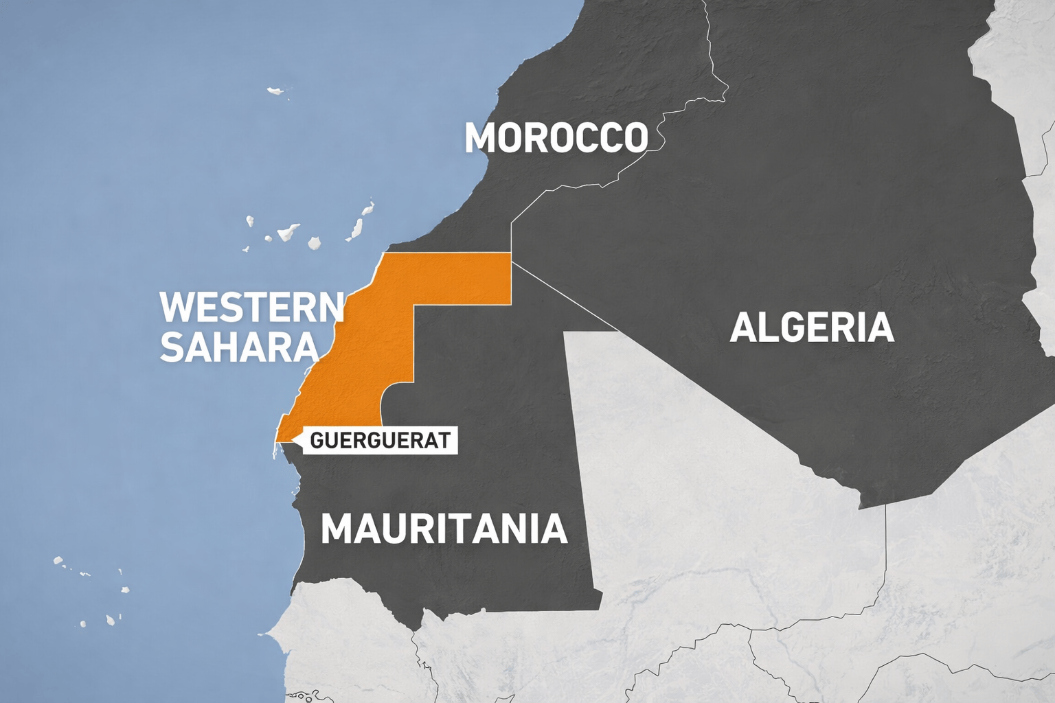
- What countries share a border with Western Sahara on a world map? - Western Sahara shares land borders with three countries. To the north, it borders <b>Morocco</b>. To the northeast, it shares a border with <b>Algeria</b>. To its east and south, Western Sahara borders <b>Mauritania</b>, extending along a considerable stretch. Understanding these neighbors is key to its exact world map placement.
- How do international organizations represent Western Sahara on their maps? - International organizations like the United Nations typically represent Western Sahara as a non-self-governing territory awaiting decolonization. Their maps often use a neutral representation, such as a dashed line for its borders, avoiding an endorsement of either Moroccan or Sahrawi claims until a resolution is reached.
- How does Western Sahara appear on most world maps?
On many world maps, Western Sahara is depicted as a distinct territory on the northwest coast of Africa. However, its borders, particularly with Morocco, are often shown with a dashed line or a different coloration to indicate its disputed status rather than an internationally recognized boundary. Some maps might integrate it fully into Morocco, reflecting a specific political stance.
- Why is it difficult to find a definitive border for Western Sahara on a world map?
The difficulty arises from the ongoing political conflict over the territory's sovereignty. Morocco claims Western Sahara as its Southern Provinces, while the Polisario Front, representing the Sahrawi people, asserts its independence as the Sahrawi Arab Democratic Republic. The United Nations considers it a non-self-governing territory, leading to varied map interpretations.
- What key geographical features should I look for when locating Western Sahara on a map?
When searching for Western Sahara, look for the long Atlantic coastline in Northwest Africa, positioned directly south of Morocco. Key geographical markers include the Tropic of Cancer running through its southern part and the expansive Sahara Desert dominating its interior. The capital, Laayoune, is a major coastal city to identify.
- Are there specific Local MAP apps that show Western Sahara differently?
Yes, different Local MAP apps and cartographic services may present Western Sahara with subtle variations. Some might show the Moroccan Wall (Berm) that divides the territory, while others might label areas differently based on their data sources and political neutrality or alignment. Always cross-reference multiple mapping services for a comprehensive view.
- What is the significance of the "berm" when looking at Western Sahara on maps?
The "berm" is a 2,700-kilometer-long sand wall built by Morocco, separating the Moroccan-controlled western part of Western Sahara from the eastern part controlled by the Polisario Front. On detailed maps, this berm might appear as a physical barrier or a distinct line, highlighting the de facto division of the territory and its military significance.
- Which countries border Western Sahara, according to world maps?
According to standard world maps, Western Sahara borders Morocco to the north, Algeria to the northeast, and Mauritania to the east and south. Its western flank is entirely along the Atlantic Ocean. Understanding these neighboring countries helps in accurately pinpointing its location within the larger African continent.
- How do I interpret the different shadings or lines for Western Sahara on an HD world map?
Different shadings or lines on an HD world map for Western Sahara typically denote its disputed status. A solid line usually means an internationally recognized border. A dashed line, a lighter shade, or an unlabeled area often signifies a territory whose sovereignty is contested or under a special administrative status. Always check the map's legend for specific interpretations.
Ever zoomed into a world map and noticed that intriguing, often ambiguous, stretch of land in North Africa? That's Western Sahara, and understanding its place on the global stage is more relevant than ever. For those of us who rely on instant info and clear visuals, getting straight to the point about this region is key. This guide is your quick rundown to spotting Western Sahara and understanding why its representation on maps can be so debated. Let's dive in and get you oriented, making sure you know exactly where to find it and what to consider when you do.
Frequently Asked Questions
Where can you specifically locate Western Sahara on a world map?
Western Sahara is situated on the Atlantic coast of North Africa, bordered by Morocco to the north, Algeria to the northeast, and Mauritania to the east and south. Its most prominent city is Laayoune.
How can I use Local MAPS to understand the Western Sahara region?
Pull up your preferred mobile Maps app like Google Maps to verify real-time geographical features and boundaries in Western Sahara. Search for major cities like Laayoune or Dakhla. Note that map representations may vary due to the ongoing territorial dispute.
What are important considerations when exploring Western Sahara on Maps?
When viewing Western Sahara on Maps, observe the often-dotted or undefined borders, which signify its disputed status. Be aware that the territory is largely controlled by Morocco, but the Sahrawi Arab Democratic Republic claims sovereignty, influencing how different maps depict the region.
Quick Local Guide List
- Region Name: Western Sahara
- General Location: Northwest Africa, Atlantic Coast
All maps focus on western sahara on world map
Western Sahara is located in North Africa bordered by Morocco Algeria Mauritania and the Atlantic Ocean. Its status is disputed primarily between Morocco and the Sahrawi Arab Democratic Republic. The territory is rich in phosphate deposits and fishing grounds. Maps often show a broken line or no distinct border indicating its unresolved political situation. Understanding its location is vital for grasping regional geopolitics.


Western Sahara Maps Mappr Western Sahara Country Location Globe . Western Sahara Location On The World Map Com Western Sahara Location Map . Western Sahara Map Video Highlighted In World Map With National Flag 1000 F 1679761323 . Western Sahara Maps Facts World Atlas Eh 02 . World Map With Western Sahara Territory Highlighted In Red World Map With Western Sahara Territory Highlighted In Red On Cream And Blue Background Vector


Western Sahara Maps Facts World Atlas Eh 01 . Western Sahara Maps Mappr Western Sahara Country Location World Map . Western Sahara On World Map World Map Centered On Western Sahara Red Country Highlighted Satellite World View Centered On The Country With Name Vector 2PF5N9Y . Western Sahara Map On World Map Stock Vector Royalty Free 759168505 Stock Vector Western Sahara Map On A World Map With Flag On White Background 759168505 . Map Of Western Sahara GIS Geography Western Sahara World Map 678x678


Where Is Western Sahara Located On The World Map Location . Large Location Map Of Western Sahara In The World Western Sahara Large Location Map Of Western Sahara In The World Small . Where Is Sahara Desert Located Location Map Of Sahara Desert Western Sahara Desert Location Map . Map Of Western Sahara Facts Information Beautiful World Travel Guide Western Sahara World Map Close Up 83437905 . Western Sahara Zoom On World Map Animated Vector Map Of The Western Western Sahara Zoom On World Map Animated Vector Map Of The Western Sahara 4k Video



Western Sahara On World Map Detailed Political Map Of Western Sahara . Western Sahara 2025 Qmg Esh Y25 Q71.webp. Premium Vector Western Sahara In Focus On The Projection Western Sahara Focus Projection World Map Has Desert Landscapes 1122597 247 . US Pressure On Algeria Over Western Sahara 2026 90a22a82 4727 4f32 B818 Scaled . Western Sahara Map Western Sahara Regions Map



Western Sahara Profile BBC News 128464836 Visual Journalism Western Sahara Territory 181120 . Africa S New Strategic Fault Line Runs Through Western Sahara Samvada World Image 4 . Which Countries Recognize Morocco S Sovereignty Over Western Sahara Map Western Sahara . Zoom From Earth To Western Sahara World Map Animation With Country 1000 F 1217801498 . Western Sahara On World Map


Western Sahara Map And Satellite Image Western Sahara Map . Premium Vector Highly Detailed Western Sahara Map With Flag Capital Highly Detailed Western Sahara Map With Flag Capital Small Map World 599062 9226 . Western Sahara On World Map Detailed Political Map Of Western Sahara With Relief Small . MAP03 Jpg The New MAP03 . Western Sahara On The Map Globe Centered To Western Sahara Country Western Sahara On The Map Globe Centered To Western Sahara Country Location On The World Map Teal Pale Mint Color Palette 3CGG5AW


Western Sahara Satellite Country And Globe Composition Stock Western Sahara Satellite Country Globe Composition Western Sahara Globe Shape Country Against Zoomed Map 187286555 . West Sahara Wikitravel Rome Western Sahara Morocco Map . War Sent These Refugees Fleeing From Western Sahara But They Insist Western Sahara Map Version 2 Mee . Western Sahara Maps Facts World Atlas Screenshot 2020 08 24 At 9 01 31 Pm . Highly Detailed Western Sahara Map With Flag Capital And Small Map Of Highly Detailed Western Sahara Map With Flag Capital And Small Map Of The World Free Vector